 The University of Maryland, Baltimore County (UMBC) research activities contributes to NOAA’s “Weather Ready Nation” goal and addresses the following objectives within this goal: 1) “Healthy people and communities through improved air and water quality”, and 2) “Reduced loss of life, property, and disruption from high-impact events”. These activities are also relevant to the “Climate Adaptation and Mitigation” goal and associated objectives: 1) “Improved scientific understanding of the changing climate system and its impacts”, and 2) “Integrated assessments of current and future states of the climate system that identify potential impacts and inform science, services, and decisions”.
UMBC research activities support Task1 (Lidar Products from the Crest Lidar Network) of the Aerosol, Water Vapor, and Planetary Boundary Layer Climatology with the CREST Lidar Network (CLN) in support of satellite validation and applications to air quality project of NOAA CREST’s Theme II: Weather and Atmosphere.
This research core studies earth system processes in the lower and middle atmosphere at a variety of scales that contribute to the National Oceanic and Atmospheric Administration (NOAA) mission of sustained observations at local, regional, and global scales, critical to a scientific understanding of the current and future state of Weather and Climate.
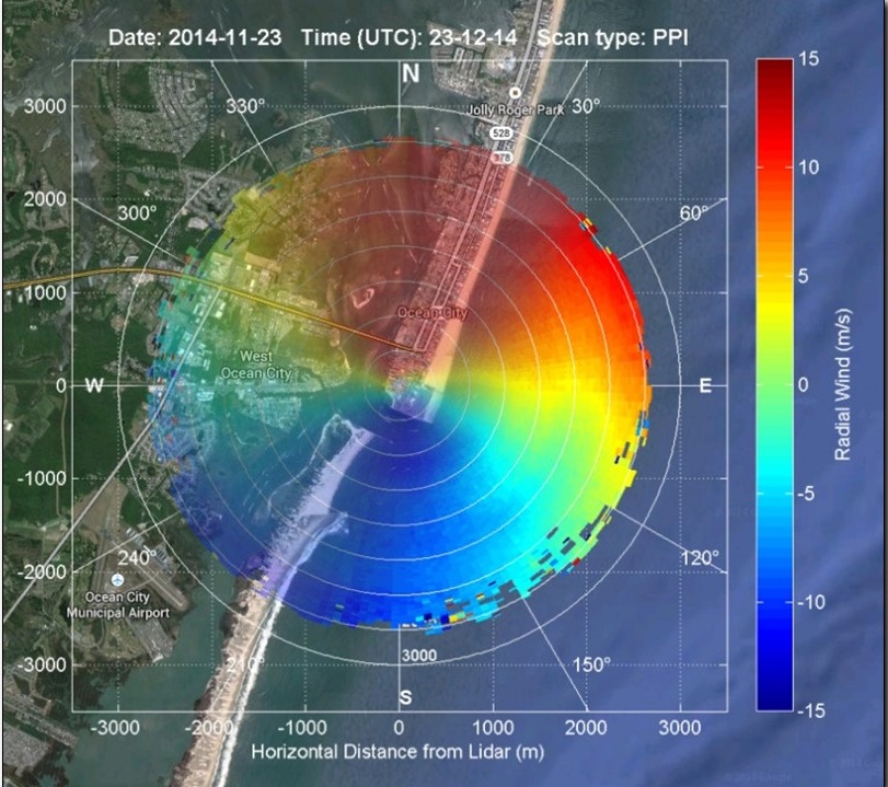
Remote sensing enables us to capture information about an entire column of air, tracking trace gases, aerosols, clouds and winds, and complement ground-based observations to understand the atmosphere’s physics, chemistry and dynamics. A key strength in this area unique to CREST has been active remote sensing for vertical profiling of the atmosphere through the establishment of the CREST LIDAR Network (CLN) of multi-wavelength LIDAR systems along the Atlantic coast (New York, NY Baltimore, MD and Hampton, VA) and the Caribbean (Puerto Rico). The network is part of the World Meteorological Organization Global Atmosphere Watch (WMO-GAW) LIDAR Observation Network (GALION), it makes regular observations that allow the understanding of planetary boundary layer (PBL) dynamics, long range transport of aerosols in aloft plumes, water vapor and wind profiling, and aerosol-cloud interactions. CLN is one the nation’s three lidar networks, as recognized by the U.S. National Science Technology Council Committee on Environment, Natural Resources, and Sustainability report titled “Air Quality Observation Systems in the United States”.
Our Research
- Elastic/Raman/Doppler wind lidars for air quality, energy, and climate-relevant atmospheric composition measurements. Coordinated CLN observations in the Eastern US and the Puerto Rico for studies continental and intercontinental plume transport (smoke, dust, volcanic ash and particle pollution).
- Global-Temporal Characterization of Cirrus and Polar Stratospheric Clouds and validation of NOAA/NASA satellite-borne retrievals of aerosol and gases remote sensing retrievals.
- Inversion algorithms for deriving atmospheric properties and variability; retrieving Planetary Boundary Layer (PBL) height; analyzing the aerosol-cloud optical properties and their interaction.
- Surface PM2.5 Estimator Development from satellite AOD measurements.
- Characterization of seasonal aerosol, water vapor and wind variability within the Coastal (Land/Marine) Boundary Layer for assessment, and validation and assimilation in Numerical Weather Prediction models for Air Quality, Energy Sustainability and Weather Forecasting. Assimilation aerosol particle size distributions (PSD) from ground or remote sensors into mesoscale atmospheric models (RAMS).
- Improvement of Satellite Products including 1) aerosol retrievals, 2) atmospheric profile under clouded atmospheric conditions, 3) combining ABI+PHS (Polar Hyper- Spectral) and 4) supporting AirQuality Proving Ground (AQPG) data.
- Satellite Remote Sensing of Ozone: Validation, Trend Analysis, and Algorithm Development.
- Development and Validation of Weather Research Forecast (WRF) model with Multilayer Urban and Energy Parameterizations.