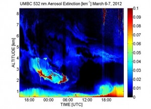
NOAA Cooperative Remote Sensing Science and Technology (CREST) Lidar Network is composed of four research stations along the Eastern United States (City College of New York, University of Maryland, Baltimore County and Hampton University) and Puerto Rico (University of Puerto Rico, Mayagüez) that contribute to the local, national and international needs for profiling aerosols in the lower atmosphere.
The active investigation of aerosol properties from Elastic and Raman lidar measurements among the sites provides high resolution information on the altitude dependence of troposphere aerosols and water vapor. This research enhances current knowledge and understanding on how vertical layering and long range transport of natural and anthropogenic particle pollution may alter the relationship between column aerosol optical depth and surface particle pollution concentrations. In addition, research efforts are focused in understanding aerosol and cloud interactions, including modifications of aerosols due to high humidity (hygroscopic properties) and assimilation of PBL heights into meteorological models.